Thursday, July 9, 2009

reflective post


Reflective post

We start learnng physical geography with a fun lesson, which Mr Heah brought us to a “hidden drainage basin”. In the lesson, he did not only teach us about geographic knowledge, bus also show us how physical geography is connected with our daily life. The reason why we should learn physical geography is that we can know more about how the surrounding environment works, thus, we can live a better life by modifying them to suit us.

In the following lessons, we had learnt how season and whether contributes. In those lessons, the most complicated is the formation of desert. The location the desert is so unique.


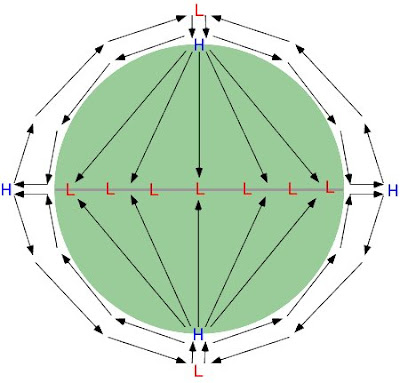
At the beginning, we thought about why desert forms and we thought it is because of the hot weather of the region. Then, we kept thinking why these regions are the hottest over the world, even hotter than the regions at the equator, we could not figure out why. Then, Ms Tang came over and tried to help us by introducing the WIND, also reminded us that hot weather is not the only reason, but also the dry weather. After the gentle reminder from Ms Tang, we changed our way of thinking. We began to think about wind system, how wind flows worldwide. Amazingly, we had discovered “three-cell system” by ourselves, in turn, figured out the formation of desert and why they located as shown in above picture.

After that, we began to explore a new world, which was RIVER. J

It was a totally new topic to me. I did not have any basic understanding before. However, I found it was quite fun after Ms Tang had touched a bit on the topic. Then, we learned drainage basin, hydrograph, features of river and so on. Many of them seemed quite complicated from the surface, however, they needed us to understand the concept. Once we understood the basic concept, which was the flow of water, it was quite easy to remember all the knowledge.

After finishing the module, I have realised that all the staffs we have learnt in physical geography are closely connected with our life. It is very important to study the surrounding environment, so that we are able to deal with them once disaster occurs, or we want to modify it to get a better living environment, but avoiding destroying them at the same time.

Therefore, I think, to get a better life, we need people to study physical geography. J


- Posted by xiangkang

Sunday, June 28, 2009

A Later Post Than The "A Really Late Post"

Hello 05 ,

I’ve been looking through at the older posts of our classmates and commenting on them. Some of them were really great posts and helped me clarify doubts which I wasn’t able to ask Ms. Tang. Also, reading through those posts helped me revise what I had been learning during these exciting geography lessons. Yes, now I believe exciting is the very word for geography, especially more so when we have Ms. Tang teaching us. (:

I believe the core of the module lies in looking at everything as a whole and linking parts up to form a complete picture. We need to think in terms of systems that interconnect with one another. These systems help regulate the Earth and we must be very careful not to interfere and affect them, since this can upset the balance of nature and harm our dear Earth and in due time, ourselves. In fact, we should actively try to prevent global problems from happening and solve existing ones like pollution, global warming to save the planet that is home to us.

These lessons have helped me find out how nature functions, something which I had always wondered but was too lazy to find out. Also, I have learned that it is quite useless to memorize stuff like a parrot without actually understanding what they mean. Knowledge acquired by memorising will never last you for a long time, and understanding about nature is much more exciting and fun. ^_^

Dat Tran

Waterfall formation

hello everyone,
all of you have mentioned a lot about the course of the river but waterfall is still left out. So I will be writing on how a waterfall comes into existence and why do they disappear after many years.
Waterfall is an upper course landform of the river where flowing water suddenly drops over a steep region. They often start as rapids or a chain of smaller steps.

So what leads to the formation of a waterfall? Usually it happens where a hard rock lies next to a soft rock. As the river continues its journey over the hard rock, the softer rock below is eroded at a faster rate by the processes of abrasion and hydraulic action. This gives rise to a cave-like formation known as the plunge pool at the base of the waterfall.
As the erosion continues, the hard rock collapses in the plunge pool due to pressure. This further erodes the base of the waterfall by abrasion leaving behind a steep sided valley called gorge.


Although the charming waterfalls that are present today will prevail for a long time, but they will eventually disappear. The hard rock gets eroded and keeps falling into the plunge pool, this way the waterfall is actually moving backwards and after sometime there will be no waterfall. This is a very slow process similar to the speed at which it is formed.
-manish

Thursday, June 25, 2009

Justa little contribution;

Hi guys, I don’t think I’ll do another recap of the hydrosphere/atmosphere modules, so yep this is a reflection plus a little something at the back!

I must say that I favored the Physical Geography modules the most among all the others, from the lithosphere to the atmosphere. Maybe it is because I’ve had some prior general knowledge with regards to this subject, from encyclopedias to internet sites. I haven’t found physical geography a chore to explore as to me it was a great way to satisfy my curiosity about the natural world surrounding us all. Though I have never actually witness a volcano erupt, nor have I been around long enough to witness the formation of a waterfall, but the fact that there is much, much more behind all these awesome works of mother nature spurs me on to learn more.

I have benefited quite a lot from these modules, and I’m sure the class did too. Probably just the nature of these lessons are key to keeping most of us (or at least me) awake. During these times all I had in mind was to learn more, unlike other subjects where I aimed to capture everything for the sake of passing exams. Say, if only we all had this attitude in every class! As for the various tests including the one in assessment week, I believe pure memorizing terms and processes or practicing default answers from worksheets won’t get anyone anywhere. We need to sit back and take a look at the big picture, understand the entire thing as whole - not individual components. With such the ‘story’ will begin to make sense and answering any question would hardly differ from extracting some excerpts from a book.

Going through these modules certainly taught us in greater detail about the lithosphere, hydrosphere and atmosphere. Though some might say these are useless bits of information that we won’t need, but I beg to differ. Such science responsible for creating our perfect little enclosure in the universe, wouldn’t it be a bit too epic to consider useless?

Isn’t it amazing how all the processes that we learnt, of haven’t come to know of, all fit in nicely in the world we know today? Without our Earth’s crust existing in many continental plates moving around, we’d be able to walk to America. Without precious water constantly renewing itself by the water cycle, it would be too polluted to support life. And with a slightly tweaked atmosphere, we’d be either cooked or frozen.

Okay now for something interesting that I came across in a book! Then I decided to look up more on it.

The pororoca. Can rivers flow backwards?

This may sound kind of impossible, because we know that the volume of water flowing along a river is so massive that it always goes downhill; in accordance to gravity, and that an unnaturally immense counter-force would be required to reverse its flow, something unheard of to many, I believe.

Well this does occur, between the months of February and March. To the mighty Amazon river. Because of its very gentle gradient along its middle and lower course (about 2mm drop every km), and its wide mouth, the largest river in the world is subject to the periodic influx of the tides of the Atlantic Ocean. When astronomically high ocean tides occur, they override the Amazon’s current, pushing inland and reversing the current for over 800km upstream. This phenomenon is called the pororoca, and highly benefits ships weighing tens of thousands of tons as it gives them a free ride upstream. The power of this inland surge generates a wave which slowly increases in height as the width of the channel shrinks, resulting in a miniature tsunami – or tidal wave – that can be over 10m high at the 360km mark.

Good luck to those near the banks.

Kay i'm done.

Aaron

Tuesday, June 23, 2009

A Really Late Post.

Hey guys,

It's nearing the end of the holidays now and yes... I'm putting up my reflective post about the subject (my only one) to add to the many others before mine.

I was quite interested in learning about physical geography at the beginning of the module as I have always been interested in learning how geographical formations like mountains and rivers were formed. I guess it's because I found it to be an easy subject to understand once I got past all the terms and memorizing. Basically I found out that many natural processes are just part of one huge system and that a small change in any one of the processes can affect the entire system. In my opinion, to do well in the module does not require one to do a lot of memorizing, just a general understanding of what was taught in class. However, I had quite a hard time to catch up with the rest of the class as the soccer nationals were on during the 2nd term and the matches were always held on the days that the lessons were on as well. However, I am quite satisfied with the effort I put into the module. This module has made me realize that we cannot take our world for granted. Also, I learnt that we humans are slowly destroying this planet as we know it and this has made me more motivated to conserve power and live a healthier, 'greener' life.

I guess that concludes my reflective post. It may not be as long as some of the others but it is an honest summary of my opinion of this module.

Chee Chung.

Wednesday, June 17, 2009

Reflections

Hello 05!


Instead of touching on content since there is already an abundance of information from our notes, I am going to blog on my reflections about the entire module.


Earlier on, I have never realised the importance and usefulness of understanding things instead of purely memorising them. As such, much time was wasted pouring through notes trying to memorise every bit of information I could before examinations and tests. However, through the many times we spent uncovering numerous ‘mysteries’ such as “How are seasons/deserts formed?” as well as hands on activities like visiting a ‘secret’ drainage basin in NJC and creating tiny clouds, I began to realise that I was employing the wrong study techniques. In fact, understanding things and knowing how to apply them is actually more useful than memorising them.


This module also led me to appreciate the way things are and how they work together to form a huge system. Previously, while I understood what global warming and climate change was, I did not know that there was actually something called the ‘planetary heat balance’ and how everything actually worked and affected each other. Furthermore, the notion of ‘how rivers/meanders/waterfalls are formed’ never once came into my mind despite the fact that I had seen them first-hand.


I have realised the importance of appreciating what we humans are given (earth, climate, etc). It has taught me invaluable information that I would not have been able to learn anywhere else, and geography, to me, is not that boring after all!


-Chang Jie


Tuesday, June 16, 2009

Hello my friends
So since the previous posts already covered the drainage basin, infiltration, the hydrological cycle, the water balance equation and hydrographs, then i guess i would cover the river channel processes.
First, we need to understand when we do get deposition then can we understand the river channel processes.
So, how do we get deposition?
The first way is when a river entering a lake or sea and the velocity of the water decreases, deposition will occur. Another way is when the example of the meander. In the inside of a meander, the velocity of the water would decrease and the friction that the water experience would increase and this will result in deposition. So just to summarize, deposition occurs wherever the speed of flow drops.


To summarize what Miss Tang taught us about the processes of erosion, just remember CASH.

C- Corrasion
when the river uses its load (the stuff that the water is carrying e.g. rock fragments) to constantly knock against the river channel's walls and beds and this will erode the river. Miss Tang would like to think it as the rocks fighting the river and the rocks would eventually win and cause some kind of gradient in the soil.
Take a look at this- http://www.geography.ndo.co.uk/animations6.htm

A- Attrition
when rocks knock against each other. This will result in the smoothing of the rocks and also make the rocks rounder and it will also break down the bigger rock fragments into smaller
pieces. Using miss Tang's words, it would be the rocks fighting each other.
Here's a link to help you understand better- http://www.geography.ndo.co.uk/animations3.htm

S- Solution (Corrosion)
When water in river reacts chemically with the minerals and other impurities and dissolve and result in a solution. Point to note- there is a difference between a suspension and a solution.
Suspension- Light particles carried by water http://www.geography.ndo.co.uk/animations7.htm
Solution- Transportation of dissolved loads
Please do get the difference right!
Actually they are all on the same website haha- http://www.geography.ndo.co.uk/animations5.htm

H- Hydraulic Action

Is when the sheer force of water weakens/loosens the cracks present in the soil of the river. Action of the flowing water that hits against the river banks and beds.
This will remove loose materials in the banks of meanders and also strong in rapids and waterfalls.

Okay that'll be all for my post. Its funny how something as small as a rock particle can cause all the difference in the huge river channel processes.

This is keewei kthx!

Monday, June 1, 2009

Summary post.


Hey guys this is ivan da blogmaster with the reflective post.

So, what did we learn this semester?

Is Geography just a study of graphs and definitions?

Is it just a classroom subject worth only mugging for mere credits?

NOOOO.

Geography is beautiful. It is the intimate understanding of how our beautiful planet works;how each cloud, each hill, each river came to be. We need geography to fully appreciate the wonders of nature.


Just take a look around you. Geography is everywhere. The air we breathe, the vast expense of sky over our heads, the rain that falls from the heavens.

If you think geography is merely a boring textbook subject, think again.


Thursday, April 2, 2009

More about Hydrographs!!!!=P

Today's lesson is just have an hour, so we don't have so many content compare with yesterday's lesson. Yeah!!=P
During today's lesson, we have discussed more about Hydrographs.
Firstly, we need to clarify some terms.
Stormflow:
stormflow contains overland flow, throughflow and direct channel precipitation.
Bankfull discharge:
Bankfull discharge is over flow the actual bank, which means flood will start to occur.
Secondly, we have discussed the factors that may change the shape of Hydrographs.
  • Amount of rain fall If there is a period of torrential rainfall, over land flow will become very significant. Thus, the gradient of the Hydrographs will become steeper, which means the graph will have steeper limbs and higher peaks.

  • Relief The steeper the long profile, the faster the stormflow. Thus, the time of rise will become shorter if the profile is steeper. The gradient of the graph will also become steeper, it may go very high, which means the graph can have very high peak flow rate.

  • Drainage density More drainage density, which means the drainage basin has more tributaries, the amount of water will also be greater. So there will be more water flow during the same time interval. Compare with the drainage basin with fewer tributaries,the graph of the drainage basin with more tributaries is higher. The graph will have steeper limbs and higher peak flow rate as well.

That's all for today's lesson.
Thanksssssss
Nianchen :)

Tuesday, March 31, 2009

Hydrological cycle


31th, March, 2009


Hi, class!
Today we learned a lot!
Basically, we can divide the content we learned today into five part

1) the teacher recap on what we learned during the last lesson -infiltration
Let's see the diagram above.
In this diagram, infiltration, overland flow and water table are labeled.
When the soil is saturated, there is overland flow instead of infiltration.

2) Input & output storages & Flows
what is input in hydrological cycle? It is Precipitation! (note: not rain, must be precise!)
Basically, Output inclueds evapotranspiration and Riverflow.
For Storages, there are 2 types of storages. Below water table, there is ground water storage, above water table, there is soil moisture storage.
For Flows, there are channel flow (river), Percolation, Throughflow and Baseflow.
Ms Tang told us, Channel flow is usually river, Percolation occurs after infiltration, when water still flow downwards in soil. Percolation can result in Groundwater storage. As for Throughflow, it is the movement of Soil moisture storage. And baseflow is the movement of the Groundwater storage.

Accoding to the order (from the surface of the ground to the deep underground), there are
-Channel flow
-Percolation
-Throughflow
-Baseflow

For Baseflow, as we can see from the diagram above, it occurs below the water table. Furthermore, it can recharge the river as where water table emerges at ground surface, it forms river/lake.

3) Roles of vegetation in the "interception" component of the hydrological cycle.
Firstly, the roots plays an important role to encourage water to pass into the soil and rock.
Secondly, vegetation slows down the water flow by reducing rainsplash erosion. So what is rainsplash erosion? In my opinion, it is like that each drop of water drips on the ground and it "hit" the ground, gradually, the soil there will be more compacted. In this way, it will decrease the rate of infiltration as it becomes harder for water to go through the soil. However, when there is vegetation, each drop of water splashes, thus, there will be a less great impact on compaction of soil. Hence, the rainsplash erosion is reduced.
Thirdly, the leaves collect water and the water is then evaporated or there will be throughfall (water drips from leaf) and stemflow ( water flows along the stem).

Also, vegetation itself needs water to sustain its life, some amount of water will be stored inside the plant organs to supply water when the plant is "thirsty" and there is no water it can absorb from the outside world.

In conclusion, vegetation really plays a very important role in the hydrological cycle. For the 2 countries which locate next to each other and share very similar geological features may still have big differences in their rainfall and climate. Presence of vegetation is also a factor which affects the local weather and climate. Or we can see it in another way. Presence of vegetation is a good indicator for the local general climate. In a dessert, it is very dry, there is little vegetation. However, in a tropical place, where there is always humid, we can see much more vegetation.

4) water balance
we need to know that there is usually a water balance in nature:

(I think this is due to the regulatory force in system, it is a negative feedback)
input=output
there is one equatin
Precipitation=Evaportranspiration+Qrunoff+change in soil moisture Storage

P=E+Q+change in S (this equation is a little bit different fromt the equation in notes, but i think this one is easier to understand and remmember!:)
there is one more thing, if we want to keep the soil moisture storage constant, what can we do? -To make the soil saturated. Thus, no more water can be stored in soil. In this way, it will result in overland flow.

5) Storm Hydrographs
this is the last part which Ms Tang went through roughly. For more details, please refer to Page 22 in your notes.
The hydrograph is a graph that shows change in discharge of a river. Discharge refers to how much water is flowing through a particular point per second (unit: m3/s)
It is a good way to record precipitation and it is useful when there is flood.

Guys, I know there is a lot which we need remmember, just try to understand it first, then I think it will be much easier to remember the tedious"scientific terminologies". Actually, I realised each terminology has its own reasonable meaning behind the word/phrase, just understand it frist. (For e.g. stemflow, water flows along the stem.) I think we can try some research on some certain case studies to know the process of hydrological cycle and the importance of water balance better.

Water is a precious resource. As we are learning geography hydrology now, let's treat water as a friend, let's have a try to know her better!


-Chengxi:D

Thursday, March 26, 2009

▁▂▃▄▅▆▇ Infiltration ▇▆▅▄▃▂▁

Haha~hello,05!! ❤

This is our first half-hour period of geo lessons. Last lesson we discussed about how water is important and essential in our life and the drainage basins. And this lesson was started with an experiment. Our class was divided into 5 groups and each group got a cup of soil and an empty cup with a drawn line on it. We poured the water into the empty cup until it reached the drawn line every time and poured the water into the cup of soil slowly, observed how water flowed inside the soil carefully. We were supposed to see the water flowed slower and slower until a layer of water was formed on the surface of soil. But in our class, all groups except our group said they saw the water flowed faster and faster. Miss Tang said it might due to some other reasons like the speed we poured the water into the soil. ☻

From this experiment we did, we could guess what will affect the rate at which water soaks into the soil which is called the infiltration capacity or infiltration rate. We deduced some factors of it, for instance, the presence of rock, the amount of water in soil, how compact the soil is, the permeability of soil and the presence of vegetation (the roots will increase the rate of infiltration). And sometimes if the amount of water received by soil exceeds the infiltration capacity of soil, it will lead a collection of water on the surface which is also can be called overland flow. Because of the limit of time, we did not learn it very concretely and I think Miss Tang will teach us more specifically to let us understand it better during next lesson. ☺

Yay, I think that’s all we have learnt in this lesson.

JIA YOU PEOPLE!!! :) :) :) :) :) :) :) :) :) :) :)

-Liu Fan- ❤

Wednesday, March 25, 2009

WATER!(:

24th March.
We had a rather exciting lesson, with the bee and all.

We were asked to write down what came to our mind when we thought about water. And we came up with things like AQUA, rain, rivers, ice and even things like pee, just to name a few. I guess this was to have an idea of what we think water is all about right at this moment before we learn anything more about it. (I don't have a picture of the stuff we wrote on the board!)

We were given a reading which was (to me) a rather big mix of chemistry, physics and even a bit of biology. It is rather cool to understand that water when frozen has a lower density as compared to water (in liquid form) so it floats and so it freezes only the top layer! By only freezing on the top layer, our dear water creatures can still live because the rest of the water isn't frozen.  Other than that, we also learnt that water is a versatile a unique molecule that is compatible for life. Water has a range 100 degrees Celsius in liquid form. And as Ms Tang said, since we are made up of 70-80% water, imagine if the range of water in liquid form is like most liquids at a range of about 20 Degree Celsius, standing out in the sun could just cause us to evaporate or experiencing winter could cause us all to freeze and become ice blocks. I really am starting to appreciate water now. [Of course, this is another reason why we should all save water.]
The specific heat of water, which is the amount of energy required to raise the temperature of a substance in this case water, is particularly high as compared to other liquids for life. It is harder to raise the temperature of water. And as we know, large portions of the Earth is covered with water and not forgetting that the changes in temperature of water bodies could result in widespread flooding, melting of glaciers. Thus, the specific heat of water helps to maintain Earth's fairly stable climate.
Another interesting fact is that water is a universal solvent! Many substances can dissolve in water.
Now we know why water is so essential for life!(:

Then we went to somewhere behind the classroom block to talk about drainage basins. In my understanding, a drainage basin is an area where water drains downhill into a body of water. So there has to be
1. water
2. relief (so the water can flow downwards)
3. land (can be soil, concrete, anything. It does not have to be of common material)


The water can fall in any part enclosed within the dotted lines and it will flow to the bottom. The brown dotted line is an imaginary line that roughly marks out each drainage basin. This imaginary line is called the water shed.

That's all for the lesson!

Shanice

Wednesday, March 4, 2009

Global Air Circulation!

Miss Tang taught us more on Global Air Circulation for today's lesson. :)

In the previous lesson, we covered the distribution of the earth's climate. After learning more about the distribution of the earth's climate, some of you might have been wondering why desserts are not found at the equator since that is where the earth receives the greatest amount of solar isolation per year.

The answer to why desserts are not found at the equator is actually because of the way air moves around earth.

Miss Tang first explained how the one cell model accounted for why desserts are not found at the equator. The one cell model is based on three assumptions.

1. The Earth does not rotate.
2. The Earth is made of similar materials.
3. Wind blows form a higher pressure to low pressure.

Based on these assumptions, air circulation on the Earth should approximate the patterns on the above one cell model.

Air flows from the poles to the equator. When the air reaches the equator, it is lifted vertically by the processes of convection and convergence. Air then flows horizontally from the equator to the poles. At the poles, the air in the upper atmosphere then descends to the Earth's surface to complete the cycle of flow.

However, the one cell model does not take into consideration planetary rotation. Planetary rotation would cause the development of three circulation cells in each hemisphere rather than one and these three circulation cells are known as the: Hadley cell; Ferrel cell; and Polar cell.


Both the polar cell and the Hadley cell are driven by heat. However the Ferrel cell is induced. Unlike the other two cells, where the upper and low-level flows are reversed, a generally westerly flow dominates the Ferrel cell at the surface and aloft. The stronger downward vertical motion and surface convergence at 30°N coupled with surface convergence and net upward vertical motion at 60°N induces the circulation of the Ferrel cell.

This three cell model can explain why desserts are not at the equator. From the pervious lesson on rain formation, we know that there must be adiabatic cooling for rain to form. Air must rise, cool and condense to form clouds. However, as observed from the diagram above, there is only sinking air at 30◦ N. Hence, clouds cannot form and thus there is no rain.

The lack of rain at 30◦ N explains why desserts are found there instead of the equator which is where the earth receives the greatest amount of solar isolation per year. :)

Lastly, remember

Good Attitude
Engagement
Ownership
Growth

Is important during Geog lessons :)

Love,
Jeanette.


Monday, March 2, 2009

WHY ARE THERE SEASONS?

HELLO PEOPLE!

Spring,
Summer,
Autumn,
Winter!

Which is your favorite season?

In today’s lesson, we discussed on the topic “Why are there seasons?”. We read through the notes Miss Lin gave to us and tried to understand it by discussion it in our little groups. The groups than sent a representative to share on what they have discussed on. However, during the first round of sharing, the explanations were rather superficial they touch briefly on the tilt of axis and the revolution of Earth around the sun. However, the explanations had no direct link to why seasons existed.

In my opinion, I feel that the main reason why such superficial answers were given was due to the fact that we were unable to visualize this system actually works. We managed to do a better job when Miss Lin gave us a second chance to relook into our explanations.

First we must know that the Earth spins on a tilted axis (23.5˚ from the plane of orbit of the Earth) about once every 24 hours. Without this tilt, no matter how the Earth revolves around the sun, there will be no seasons as every point of the earth will not experience any change of intensity of sunlight. All seasonal changes are driven by changes in the amount of the Sun's energy. This is one of the most important reasons for seasons.

In addition to the earth rotating around its axis, the Earth completes one revolution around the sun about once every 364 1/4 days. The diagram above illustrates the various positions of the earth around the sun. The darker part of the globe represents the part of the earth that does not receive sunlight while the brighter part of the globe represents the part of the earth that receives sunlight at that period of time. The red line on the globe represents the equator. This equator will divide the earth into halves, North and South Hemispheres.

Why is the equator the hottest?
Although every part of Earth which is facing the sun receives the same amount of light rays, the rays at the poles are spread out over a larger surface area compared to equators. Therefore, the intensity of light rays is greater at the equator. Refer to Figure 1.

Figure 1.


At 1, December 21-22, the southern hemisphere experience the longest day as it has the maximum tilt towards the sun. This means that it will receive a great amount of insolation and it will be warmer. On the other hand, the northern hemisphere experience the shortest day as it has the maximum tilt away from the sun. This means that it will receive a small amount Hence the North Hemisphere will experience winter while the South Hemisphere will experience summer.

At 2, March 21-22, the hours of day and night gradually become the same. Therefore, this means that the temperature is generally the same in the two hemispheres. Due to the fact the number of hours spent during the day in the South Hemisphere is shorter compared to that of the season prior to it, the temperature will drop. On the other hand, the North hemisphere generally becomes warmer. Hence, the North hemisphere will experience spring while the South hemisphere will experience autumn.

Okay, so here’s the main gist of the lesson. : )
Jia you for assessment week! XD
<3 Melissa-Raye Teo

Tuesday, February 24, 2009

TILT AND SHAPE!!!

In my opinion, today's lesson was quite interesting and it was something like self-study with the assitance of our geog teachers. We tried to explain two important things which were the distribution of the Earth's climate and the reasons why there are seasons on Earth.

Chengxi, Kah Eng and I were in the same group and our task was to discuss and explain the distribution of Earth climate.

From the World map of Koppen-Geiger Climate Classification, there are some things we noticed, some we could explain and some we couldn't or couldn't explain totally:

The nearer to the equator, the hotter it is: Our Earth orbits the Sun in an ellipse motion, it also spins on its own arround an imaginary axis which is tilted 23.5o. As a result, the equator is the part receives the most solar radiation, faraway from the equator, the less solar radiation there is, especially the North and South Poles, where the temperature is usually negative through out the whole year.

The different areas at the same lattitude usually have the same or similar kind of climate due to similar amount of solar radiation received. Moreover, there is symmetry between the Northern Hemisphere's climate and the Southern Hemisphere's climate. For example, (10 N, 20 E) and (10 S, 20 E) are the two places having Aw- Equatorial winter dry due to similar amount of solar radiation they receive as well.

Although equator receives the most amount of solar radiation, that area is not the hottest part on Eart. Deserts in Africa, Australia, Southern Asia and some parts of America are actually the hottest places on Earth, there might be different explanations regarding this phenomenon and we hope to know it the next lesson.

Chengxi also noticed that why the climare of the area connects the North and South of America continent is Am (equatorial monsoonal) and As (equatorial summerdry) even though it is at the same lattitude as the lower part of Sahara desert in Africa. I think one of the reason maybe it is a very thin stripe of land so that it has more contact with the sea, has more water vapor and become less dry....

The circulation of the wind between the two poles and the equator is partly due to the air pressure and the temperature. Air in the North and South Poles is colder, it has higher pressure and it sinks while air in the equator is hotter with lower pressure. Convection causes the cold air in the North and South poles to sink and flow to the equator while hot air near above the equator will rise and flow to the two poles.

Sea currents may affect our Earth's climate distribution as well.

That's all I have noticed about today's lesson, in the next lessons, I hope we can have a better understanding of the climate patterns.

Please comment this entry so I can improve on it :D
Linh :)

Friday, February 20, 2009

20-02-2009

In today’s lesson, we did some practices about describing climographs and then later on we did reflection about what we have learnt in this module :)


#First, I’ll touch on the climograph describing:
As mentioned in our previous lesson, there are some major points we should mention about climographs:
- Temperature: range + peak.
- Precipitation (rain, hail...): pattern, range (note: precipitation must come in mm)
- (Optional) sometimes elevation can also be used to describe climate.
Today we did some practices on climographs, and along the way, I picked out some points that should be noted:
- Some key words that should be used: seasonal, range (narrow/ wide), dry/ wet season, cold/hot, constant/variable, etc...
- Must pick out the general trend (eg: wetter months...)
- We can use the World map of Koppen- Geiger climate classification (the colourful map we were given) to locate the area where we’re describing and then we will know what’s the climate there.
- Climate of one area can be seasonal / not seasonal :D
- General statements should go first.
- There is no such thing as precipitate rate, just precipitate alone can do already.
- Take the graph as a circular system (cos every year we always have 12 months right? So instead of listing all the months like “December, January and February”, we can just say “from December to February”)
Most importantly, there’s no need to learn by heart any climograph description because we’ve known every necessary things to describe climographs. YOU KNOW IT, SO JUST DO IT!


#Now is our reflection!!!!!!!!!!!!!!!!!!!!! Basically we just mentioned what we have learnt in this module and connect all those things into a system so that we can see the relationship of all the stuff we’ve learnt :)


Yah, so that’s all we did today.
Cheers everyone!!!!!!!!!
Thu :)